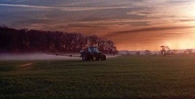
Air temperature inversions – when air temperatures actually increase as you get higher above the ground – create ideal conditions for tiny spray droplets to become suspended in the air and drift considerable distance from their target. This cool air mass hovering near the ground can flow like water to valleys and lower areas. Early mornings and evenings can be challenging times for spraying because of air temperature inversions.
The following factors often signify that an air temperature inversion is in play:
- Large temperature swings between daytime and nighttime conditions
- Very calm (<3 km/h wind) and clear conditions
- Intense high pressure and very low humidity
- Mist, fog, dew and frost
- Smoke or dust hangs in the air and/or moves laterally in a sheet
- Odours seem more intense
- Daytime cumulus clouds tend to collapse toward evening
- Overnight cloud cover is 25% or less
- Soil conditions that make inversions worse include low soil moisture, freshly tilled, coarse soils, heavy residue, closed crop canopy.
Air temperature inversions rarely happen during the day – with very rare exceptions related to cold air moving in from a body of water, or a strongly transpiring crop canopy. However, inversions are common at night. In fact, you can assume the atmosphere starts to become inverted as the sun sets, that the inversion will build in strength overnight, and that it reaches its peak height and severity at sunrise.
Therefore, if it’s late evening, night or early morning, assume you have a temperature inversion unless you have (1) pretty consistent winds and (2) pretty solid cloud cover.
More…
- Canola Encyclopedia on spray drift prevention
- NDSU Extension Service provides this useful factsheet: Air Temperature Inversions
- Sprayers 101 article on inversions and vapour drift
- Canola Watch podcast on inversions